




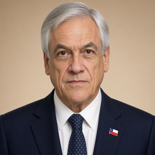
President Piñera announces international claim over underwater territory between Rapa Nui and the continent.
 Sebastián Piñera · President of Chile
- Context
- Piñera announced Chile's formal UN submission claiming an extended continental shelf beyond 200 nautical miles around Easter Island and the Antarctic territory in October 2020.
- Main themes
- Extended continental shelf claim, Easter Island (Rapa Nui) sovereignty, United Nations Convention on the Law of the Sea, maritime zones, Chilean territorial integrity, Nazca Plate geology, Antarctic territory, sovereign rights over natural resources, international submission, tricontinental identity of Chile
- Duration
- ~6 min
- Words
- 717
- Sentences
- 26
- Readability
- 27
- Grade
- 16.4
- Syntax
- 3.24
- Vocabulary
- 2.71
Translated from Spanish
The broad sphere of national life a sentence belongs to. Every sentence has an Arena, so it is the denominator the other indices are read against.
Other26 sentences in 23 paragraphs
Chile is a tricontinental country, with a presence on three continents: America, Oceania, and Antarctica.
The territory of Chile is classified into three geographical zones:
Continental Chile, which extends for 4,270 km, between the Andes Mountains and the Pacific Ocean.
The Chilean Antarctic territory, with an area of more than 1 million square kilometers that projects down to the South Pole.
Insular Chile, which groups a set of islands, such as the Juan Fernández Archipelago and the Desventuradas Islands, belonging to South America, and Salas y Gómez Island and Easter Island, located in Oceania.
Additionally, Chile has a rich and extensive coastline of more than 6,435 km in length, from which four maritime zones are projected: territorial sea, contiguous zone, economic zone, and continental shelf.
During our 210 years of independent life, the cause of our sovereignty and territorial integrity has received significant contributions and achieved important advances such as:
O’Higgins' concern for Magallanes.
The taking of possession of the Strait of Magellan.
Adherence to the Convention on the Law of the Sea.
The 200 nautical miles of maritime zones.
Today we are going to take a new and important step, which continues the valuable legacy of the generations that preceded us, to safeguard our sovereignty over the continental shelf.
The continental shelf is the underwater territory that is generated by the natural extension of our territory under the sea. Over this Shelf, Chile has sovereignty to carry out the exploration, protection, and use of its natural resources, as recognized by international law and the United Nations Convention on the Law of the Sea.
Eleven years ago, Chile submitted a first report to the United Nations indicating that our continental shelf could extend beyond the 200 nautical miles in some of its territories.
This special situation, which allows us to have an extended continental shelf with sovereignty, occurs in Easter Island and Salas y Gómez Island and the Chilean Antarctic Territory. And it could also exist in other territories, such as: the Taitao Peninsula, the Juan Fernández Archipelago, and the San Félix and San Ambrosio Islands.
Today I want to announce that in the coming days Chile will deliver to the United Nations our first partial submission of the Extended Continental Shelf of the Province of Easter Island, which is composed of two islands: Easter Island, whose historical name is Rapa Nui, and Salas y Gómez Island, whose historical name is Motu Motiro Hiva.
The objective of this submission is for the United Nations Commission on the Limits of the Continental Shelf to validate the extension of our continental shelf in the Province of Easter Island, beyond the 200 nautical miles.
We will present to that Commission the results obtained after 10 years of extensive and challenging scientific studies of bathymetry and geophysics of our seabed, which demonstrate the enormous extension of the extended continental shelf of the Province of Easter Island.
Our studies have shown that the movements of the Nazca Plate, over millions of years, have created a mountain range of volcanoes, similar to the elevations of the Andes Mountains. This mountain range today forms the seabed of that area and constitutes the Continental Shelf of Salas y Gómez Island, which exceeds 350 nautical miles, and could extend up to 700 nautical miles.
This means that Chile has sovereign rights over an area of 550,000 square kilometers, equivalent to all the continental territory between Arica and Aysén.
I also want to announce that next year Chile will deliver to the United Nations the Partial Submission of the Extended Continental Shelf of the Chilean Antarctic Territory, to strengthen and safeguard our sovereign rights over the Chilean Antarctic territory and its marine spaces.
Following the tradition of all previous Governments, our Government has paid permanent and rigorous attention to the protection of our sovereignty and territorial integrity, not only because it is a duty of every ruler, but also because it allows us to better fulfill our obligations to protect our citizens, our nature, and our environment.
I conclude these words by sincerely thanking the valuable and committed work carried out by the team of the Ministry of Foreign Affairs, the Directorate of Borders and Limits, the Chilean Navy, the National Committee of the Continental Shelf, and the scientists from the Universities of Chile, Católica, and Concepción.
The original Spanish. The tags above are read on the English translation's sentences.
Chile es un país tricontinental, con presencia en 3 continentes: América, Oceanía y la Antártica.
El territorio de Chile se clasifica en 3 zonas geográficas:
El Chile continental, que se extiende por 4.270 km, entre la Cordillera de Los Andes y el Océano Pacífico.
El territorio chileno antártico, con una superficie de más de 1 millón de kms2 que se proyecta hasta el Polo Sur.
El Chile insular, que agrupa un conjunto de islas, como el Archipiélago de Juan Fernández y las islas Desventuradas, pertenecientes a Sudamérica, y la Isla Salas y Gómez y la Isla de Pascua, ubicadas en Oceanía.
Adicionalmente, Chile cuenta con una rica y extensa costa de más de 6.435 km de extensión, a partir de la cual se proyectan 4 zonas marítimas. El mar territorial, la zona contigua, la zona económica y la plataforma continental.
Durante nuestros 210 años de vida independiente la causa de nuestra soberanía e integridad territorial ha recibido grandes aportes y logrado importantes avances como:
La preocupación de O’Higgins por Magallanes.
La toma de posesión del Estrecho de Magallanes.
La adhesión a la Convención del Mar.
Las 200 millas de zonas marítimas.
Hoy vamos a dar un nuevo e importante paso, que continua con el valioso legado de las generaciones que nos antecedieron, para resguardar nuestra soberanía sobre la plataforma continental.
La plataforma continental es el territorio submarino que se genera por la prolongación natural de nuestro territorio bajo el mar. Sobre esta Plataforma Chile tiene soberanía para realizar la exploración, protección y uso de sus recursos naturales, tal como lo reconoce el derecho internacional y la Convención de las Naciones Unidas sobre el Derecho del Mar.
Hace 11 años, Chile presentó un primer informe ante las Naciones Unidas indicando que nuestra plataforma continental se podría extender más allá de las 200 millas marinas en alguno de sus territorios.
Esta situación especial, que nos permite tener una plataforma continental extendida con soberanía, ocurre en las Islas de Pascua y Salas y Gómez y el Territorio Chileno Antártico. Y podría existir también en otros territorios, tales como: la Península de Taitao, el Archipiélago Juan Fernández, las Islas San Félix y San Ambrosio.
Hoy quiero anunciar que los próximos días Chile entregará a las Naciones Unidas nuestra primera presentación parcial de la Plataforma Continental Extendida de la Provincia de Isla de Pascua, la que está compuesta por dos islas: la Isla de Pascua, cuyo nombre histórico es Rapa Nui, y la Isla Salas y Gómez, cuyo nombre histórico es Motu Motiro Hiva.
El objetivo de esta presentación es que la Comisión de Límites de Naciones Unidas valide la extensión de nuestra plataforma continental en la Provincia de Isla de Pascua, más allá de las 200 millas.
Presentaremos ante esa Comisión los resultados obtenidos tras 10 años de extensos y dificultosos estudios científicos de batimetría y de geofísica de nuestro fondo marino, que acreditan la enorme extensión de la plataforma continental extendida de la Provincia de Isla de Pascua.
Nuestros estudios han demostrado que los movimientos de la Plaza de Nazca, durante millones de años, han creado una cadena montañosa de volcanes, similar a las elevaciones de la Cordillera de Los Andes. Esta cadena montañosa hoy conforma el fondo marino de esa zona y constituye la Plataforma Continental de la Isla Salas y Gómez, que supera las 350 millas marinas, y que podría extenderse hasta a las 700 millas marinas.
Esto significa que Chile tiene derechos soberanos sobre un área de 550 mil kilómetros cuadrados, equivalentes a todo el territorio continental entre Arica y Aysén.
Quiero anunciar también que el próximo año Chile entregará a Naciones Unidas la Presentación Parcial de la Plataforma Continental Extendida del Territorio Antártico Chileno, para fortalecer y resguardar nuestros derechos soberanos sobre el territorio chileno antártico y sus espacios marinos.
Siguiendo la tradición de todos los Gobiernos anteriores, nuestro Gobierno ha prestado una permanente y rigurosa atención a la protección de nuestra soberanía e integridad territorial, no sólo porque constituye un deber de todo gobernante, sino también, porque nos permite cumplir mejor nuestras obligaciones de proteger a nuestros ciudadanos, a nuestra naturaleza y a nuestro medioambiente.
Termino estas palabras agradeciendo sinceramente el valioso y comprometido trabajo realizado por el equipo de la Cancillería, la Dirección de Fronteras y Límites, la Armada de Chile, el Comité Nacional de la Plataforma Continental y los científicos de las Universidades de Chile, Católica y de Concepción.